Within the WAM model, the basic equation is the wave action balance equation with a wave field spectrum in the two-dimensional frequency and direction space.
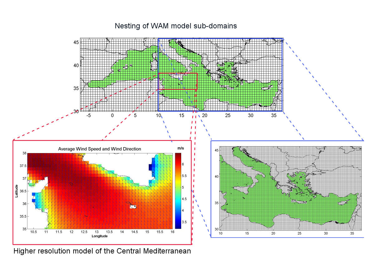
The energy equation is forced by a source term related to the near-surface atmospheric wind. The Model is forced by surface wind field from the MARIA/Eta atmospheric forecasting system, and runs once per day (starting at 12 UTC) to prepare a 72-hour forecast. Subsequent model runs are initialized using the sea state at analysis time, calculated from the previous run as a 24- hour forecast. The model is set-up as a 2-step nested system starting from a coarse grid covering the whole Mediterranean region at a resolution of 0.50º in both longitude and latitude direction. The intermediate grid domain is nested within the coarse grid and covers the Eastern Mediterranean region (east of 10º E) with grid resolution of 0.25º. A further high-resolution grid (resolution of 0.125º) over the Central Mediterranean is nested within the intermediate East Mediterranean grid. Details on geometry and resolution of three domains are given in Table 1.
|
Grid |
South boundary |
North boundary |
East boundary |
West boundary |
Region |
Resolution |
Coarse |
30º |
46º |
-7º |
37º |
Mediterranean |
0.5º |
Medium |
30.5º |
45.5º |
10º |
36.5º |
Central and Eastern Mediterranean |
0.25º |
Fine |
35º |
39º |
10.25º |
16º |
Central Mediterranean |
0.125º |
The model set-up is based on the following run-time parameters: 30 frequencies (in the range from 0.041772 Hz to 0.66264), 24 directions (every 15 degree), 3 output grids, 4916 sea points, and 3-hour outputs. The time integration step is 1200 sec. The 2’ resolution bathymetry of Smith and Sandwell (1997) is used for producing the bathymetries. The original bathymetry data set is interpolated into related bathymetries for each of the 3 different output grids in the model set-up. The 6-hourly wind data used as input to the WAM model is generated by the ETA regional atmospheric model at the 0.5º resolution. The Mediterranean is treated as a closed basin, assuming no wave energy exchange with the Atlantic or the Black Sea. The output parameters from the WAM wave model are: significant wave height, mean wave direction and frequency of total sea, wind waves and swell.