 |
| |
| Mission | |
| Meteo-Marine Observations | |
| Numerical Modelling | |
| MedGLOSS Malta Station | |
| International Projects | |
| How To Find Us | |
| Contact Us |

MedGLOSS is an IOC/CIESM pilot project that is building an operational sea level monitoring network system for systematic measurements in the Mediterranean and Black Seas. The system is based on the basic GLOSS requirements and methodology, aiming to provide for the first time a high quality standardized data on sea level in near real-time with a coverage along the Mediterranean and Black Sea basins.
| Sea level monitoring is important for studies on global climate change and sea level rise. A worldwide eustatic sea-level rise has been forecasted by the WMO/UNEP Intergovernmental Panel on Climate Change (IPCC) with major factors causing this sea-level rise being the ocean water volume expansion and ice cap melting due to global warming. From the regional perspective sea-level rise may differ significantly from the globally averaged sea-level rise forecasts, in particular due to tectonic movements. Simultaneous absolute sea level observations taking account of geodetic movements and with sufficient spatial coverage are thus necessary to better understand the signals of sea level trends and variability in the region. |
|

Sustained simultaneous hydro-meteorological measurements covering the whole region will also open the way for a comprehensive study of the basin and sub-basin responses of the water body to external forcing. The extensive geographical coverage and duration of observations will permit the identification of commonalities and differences in mechanisms responsible for long wave signals that have regional scale signatures as compared to those occurring on the shelf and in the coastal areas, as well as enable to study the dependencies of the latter smaller spatial scale oscillations on the regional scale dynamics and basin wide influences and controls.
On a more local scale the use of the sea level data is essential for shipping and harbour operations, for the impact of storm surges, for studies on salt intrusion in aquifers, for the estimation of extreme sea levels in connection with the building of coastal structures, and other applications. When a sufficiently long data series becomes available it is also possible to model the effect of wind and atmospheric pressure on the mean sea level on a local scale and hence permit a more precise prediction of sea levels including the prediction of surges.
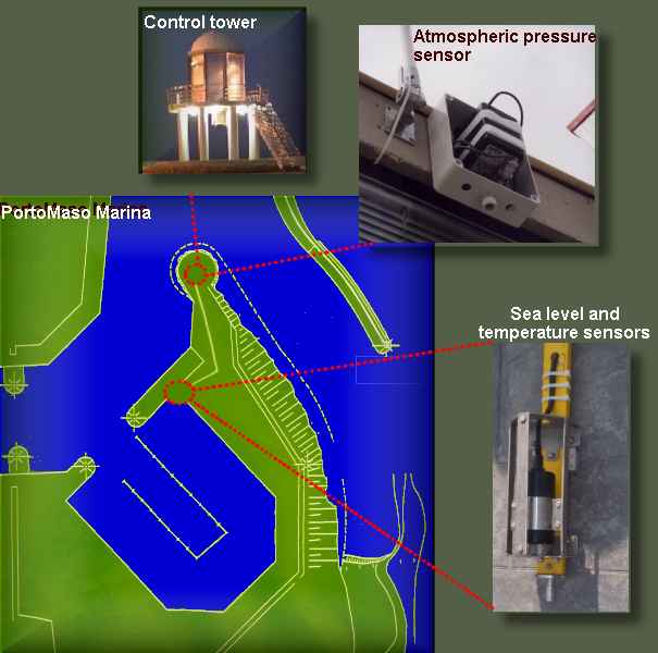
Malta hosts one of the node stations of the MedGLOSS Network. The installation of sea level gauge was completed in February 2001 in the Portomaso marina at the Malta Hilton in St. Julians and constitutes the first real-time monitoring station for oceanographic data in Malta. The instrument, donated by the International Commission for the Scientific Exploration of the Mediterranean Sea (CIESM), collects sea level data (every half-a-minute), seawater temperature, atmospheric pressure and waves in the marina.
|
|
Hourly averaged observations are shared in real-time with the MedGOOS network through the Israel Oceanographic and Limnological Research (IOLR) that co-ordinates and controls the project. These data are presented in twice-daily updated graphical representation on this website (click here for update). Data are also achieved at the Permanent Service for Mean Sea Level (PSMSL) centre in Bidston, UK which is the global data bank for long term sea-level change information from tide gauges. Malta, together with Israel, was instrumental within CIESM to promote and prepare the launching of MedGLOSS. It is envisaged that Malta will also host a GPS MedGLOSS station in the near future, and to become a regional centre for the Central Mediterranean area. |
Description of the Malta
Station____
The equipment of the station includes:
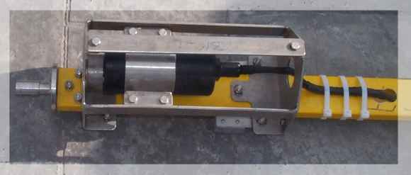
- an underwater pressure sensor of Paroscientific manufacture, type Digiquartz Intelligent sensor, model 8DP060-1 with an RS-232 communication cable
- Setra atmospheric pressure sensor, type 470
- Trimble GPS timer computer card and antenna for accurate time recording
- Computer serving to process and store data
- Server to interrogate and transmit data in real-time
The ISRAMAR package of computer programmes integrated in a unified system provides near real-time data gathering and transmissions. At the receiving end, the software automatically controls the quality of the data received for the MedGLOSS station, including automatic regular submission of status to the operator by email messaging.
Underwater Sensor |
|
| The underwater sensor is 10cm in diameter and 25cm long. It is housed in a stainless steel protective frame whose diameter is 15cm and 60cm long. It is attached to a 1” diameter stainless steel rod which is approximately 1m long. The rod is inserted underwater into a vertical stainless steel tube slightly larger than 1” inner diameter, welded to a horizontal stainless rod, which is attached to a steel plate (40cm x 40cm x 2cm) found attached to the quay in situ at about 3m (in a total depth of 3.5m) below sea level.
|
|
 |
Atmospheric Sensor
|
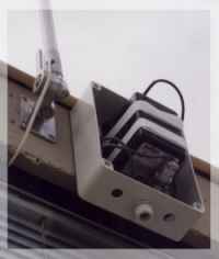 |
| The
Setra 470 Digital Pressure Transducer is a highly accurate pressure
measurement system, utilizing the patented SETRACERAMTM sensor,
advanced micro-computer based electronics, and sophisticated firmware.
The Setra 470 accurately measures and reports barometric pressure.
The digital design of the Setra 470 provides a simple and reliable
communications interface for easy integration into digital control
systems. This, in addition to the digital signal processing of the
sensing element signal, allows the elimination of inaccuracies and
cost of an analogue data acquisition module. |
Maintenance of Equipment
The underwater sensor is cleaned regularly. The process includes the cleaning of the underwater pressure sensor and its orifice, and its underwater cable. The atmospheric pressure sensor is cleaned of dust once in a few months. Recalibration of the underwater sensor is done at least once every 2 years at the mother company.
Description of data and real time transmission
| The sea level station registers data every half minute on a computer on site. This computer communicates data with a server at the University of Malta. The sea level station is interrogated every hour by the server. The shortest packet of data is on the first hour of the day.Successive | |
| hours transmit also the previous hourly data packets of the day. The largest packet is on the 24th hour and is about 1K in size. This daily cycle of data transmission is fully automated. Daily files and charts of hourly averaged values of sea-level, water temperature and atmospheric pressure are available from this site. Agencies which are interested to subscribe for direct access to the data can contact Dr. Aldo Drago (responsible for the Malta MedGLOSS station). |
|
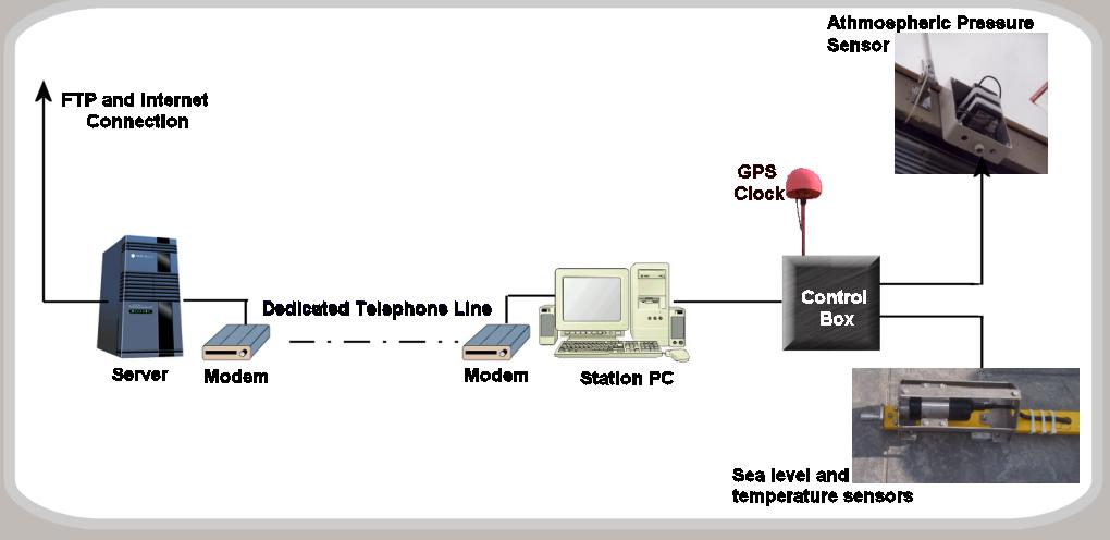 |
| Data and real time transmission system |
| Click
image to enlarge |
MedGLOSS Pilot Network____
The pilot network was initially planned to include some 27 stations in 13 countries which have expressed their interest in joining this international research network. It includes the five GLOSS sea-level monitoring stations operating in the region.
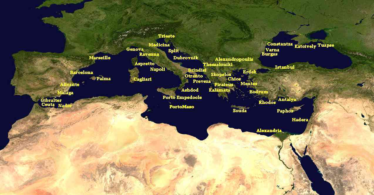 |
| Map of MedGLOSS pilot network of sea level stations (originally planned in 1999) |
| Click
image to enlarge |
So far MedGLOSS sea level stations have been established in Costanta (Romania), Dubrovnik (Croatia), Portomaso (Malta) and Paphos (Cyprus). The Katcively sea-level station in Ukraine is the next in line to be upgraded to MedGLOSS standard in early 2003. Contacts with NIOF (Egypt) and (FSR) Morocco are in hand and new installations at these two important locations are being considered.