Physical Oceanography Unit launches the MEDSLIK oil spill model for the Maltese Islands |


The Mediterranean Sea and its coastal communities face a permanent risk of oil spill pollution. Some 20% of global oil transported by sea crosses this basin, and oil exploration platforms dot various parts of it. The presence of oil and petroleum residues in the marine environment result also from abusive spillages by ships and boats to the detriment of marine ecosystems and to coastal resources when oil impacts on land. All this proves the importance for Mediterranean coastal states to commit efforts for the organisation and preparation of an operational response for marine oil pollution accidents, even more so in the Central Mediterranean and the shelf seas around the Maltese Islands, which are major transit zones for maritime traffic. The Physical Oceanography Unit (PO-Unit) at the IOI-MOC (International Ocean Institute - Malta Operational Centre) of the University of Malta has developed an application of an oil spill model MEDSLIK for the maritime areas around the Maltese Islands. This model predicts the fate and evolution of an oil slick in the Malta Channel and the approaches to the Maltese Islands, and is able to anticipate likely impacts on the coast for early warming and mitigation. It also provides a tool for planning an effective response to keep oil away from key coastal resources. This work was co-ordinated by Dr. Aldo Drago in collaboration with a Cypriot expert, Prof Robin Lardner. The activity was conducted within the ambit of an EU funded project, MAPRES-Marine Pollution Monitoring and Mitigation by Remote Sensing. The use of computer models predicting the movement and weathering of oil helps to make optimal use of the various measures and equipment that can be employed in case of an oil spill accident. Models can predict the expected state of the oil when it arrives at a given location, that is, how much will have evaporated, the degree of emulsification of the remainder, how much will be dispersed as fine droplets through the water column, where the oil spill will most likely move to, how soon it will get there and which resources are threatened by it. This modelling tool proves to be a very important tool to local civil protection and maritime authorities to combat oil pollution. It allows simulations with different dispositions and positioning of booms to be run in order to assess the most adequate response. Trained personnel can then act to mitigate the effects of pollution more effectively. MEDSLIK can also compute and plot simple trajectories of floating objects. This is especially helpful to locate floating objects that are drifting on the sea surface. Search & Rescue operations can narrow the search area and locate people lost at sea in a shorter time. |
|
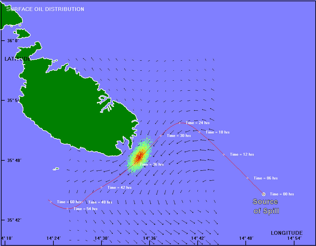
The simulated trajectory and progression of a possible threat from an oil spill approaching Malta from the SouthEast. (Click on image to enlarge)
|
|
The above risk from the oil industry and the oil transport imposes the need of organising and preparing an operational response to accidental marine pollution |


The oil spill model relies on accurate input data, namely the type of oil and its characteristics, forecasts of wind fields, sea temperature, currents and sea state. The Malta MEDSLIK oil spill model makes use of the ROSARIO II Forecasting System, which provides operational marine forecasts of sea surface temperature, currents and the wind field. Forecasts are published daily 3-hours averaged fields by the PO-Unit on a dedicated website.
As part of the MAPRES project, the oil spill model was recently successfully tested in a simulation exercise conducted by the Italian Coast Guard off the coast of Pozzallo. The aim was to compare the actual path followed by an artificial slick to the oil trajectory forecasted by the model. Observational data of the slick movement was recorded by the ‘Nucleo Aereo Due - Guardia Costiera’ with the use of their dedicated remote sensing aircraft.
The PO-Unit is the local entity engaged in oceanographic research covering coastal meteorology, hydrography and physical oceanography with a main emphasis on the study of the hydrodynamics of the sea in the vicinity of the Maltese Islands. The PO-Unit promotes activities in operational oceanography by the installation and maintenance of permanent meteo-marine monitoring systems, and the provision of atmospheric and marine forecasts which can be accessed from the CapeMalta website. A meteo-monitoring station on the breakwater of Marsaxlokk provides meteo observations in real time on www.capemalta.net/MARSAXLOKK, while the Malta MedGLOSS station in PortoMaso provides updates on sea level and temperature on www.capemalta.net/pounit/levmalta.html. The PO-Unit also specialises in data management and analysis, including participation in international cooperative ventures. Activities include climatological studies of winds and waves in the Central Mediterranean area including the Maltese Islands. These datasets provide important baseline information for climate studies.